If you have already hiked the marked hiking trails and you are fascinated by the adrenaline and beautiful views from the highest peaks of the Tatras, you can use the services of professional mountain guides who will accompany you safely to your chosen peak and of course back.
Ascent to Gerlachovsky peak
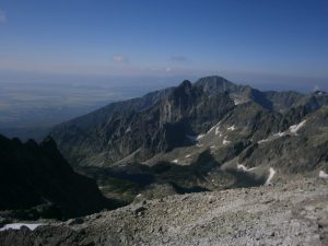
The most popular and most visited peak is the highest peak of the High Tatras Gerlach with an altitude of 2655 m.
You can choose from several ascent options according to technical difficulty.
In the summer, the classic ascent leads through Velická próba and Velický žľab to Sedielko nad Kotlom at an altitude of 2425 meters above sea level, then through a traverse over the Gerlachovský kotol to Štrbina pod Kotlovým at an altitude of 2550 meters above sea level and through parts like Okno and Počúvaj couloir to the top. The descent leads through Batizovský žľab and Batizovská próba to Batizovská dolina and around Batizovské pleso back to Sliezsky dom.
Total Ascent: 1035 meters
Duration: 8-10 hours
In good conditions (dry rock), a mountain guide can lead on a rope a maximum of 3 people.
In the transitional period, the beginning of summer/winter, when the standard route through Velická próba is technically demanding, there is a common ascent as well as descent through Batizovská próba.
Tatarkova próba ascent is a more technically demanding ascent. From the hiking trail through Velická dolina you’ll turn at the tarn Dlhé pleso. Tatarkova próba follows – an ascent secured by chains and artificial tools which continues to the right side of Tetmajer’s couloir, it ascends towards Gerlachovské sedlo and to Zadný Gerlach.
From Zadný Gerlach you walk along the exposed ridge over Gerlachovské sedlo to the top of Gerlach. Descent usually through Batizovská próba.
Duration: circa 9 hours.
Maximum amount of clients: 2
The most technically demanding ascent is a route called Martinova cesta.
The ascent first leads through the Velická valley to Litvorové sedlo, where the climbing begins. After the start of the ascent, we climb directly along the ridge over the peaks Malá Litvorová veža, Veľká Litvorová veža, Lavínová veža, Lavínový štít, Zadný Gerlach and further to the top of Gerlachovský štít.
Total Ascent: 1055 m
Duration: 8 – 10 hours
Maximum amount of clients: 2

Zdroj ZCR VT
Ascent to Vysoká
Vysoká is one of the most beautiful and frequently visited peaks in the High Tatras. It has an unmistakable shape and is an ornament of the Tatra panoramas. It has an altitude of 2650 meters above sea level and rises in the main ridge between the Mengusovská and Bielovodská valleys, more precisely above their branches Rumanová, Drača and Česká dolina.
The ascent to it by the classic route begins at Popradské pleso. We continue through Zlomisková dolina and after about 2 hours we come to Dračie sedlo. From Kotlinka pod Dračím sedlom we continue through a south-western notch to the central couloir and through it to Štrbina Vysoká. About 30 meters below Štrbina, we turn left and climb a rock plate secured by iron tools to the northwestern peak of Vysoká, which is slightly higher than the southeastern peak.
The descent usually leads through Štrbina pod Kohútikom and the saddle Váhy to Chata pod Rysmi and back to Popradské pleso.
Total Ascent: 1060m
Difficulty: medium
Duration: circa 8 hours

FOTO: Marián Jacina
Ascent to Lomnický štít
The second highest peak is Lomnický štít with an altitude of 2633 meters above sea level, which is accessible as the only peak in the High Tatras by cable car from Tatranská Lomnica.
Several ascent routes lead to the top of Lomnický štít:
The easiest and most popular of them is the ascent from Lomnické sedlo, which is also suitable for beginners. We take the cable car to Skalnaté Pleso and from there a chairlift to Lomnické sedlo.
Total Ascent: from Lomnické sedlo 443 m
Difficulty: easy
Duration: 4 hours
The second most popular, but technically more demanding is the ascent by Jordánova cesta route with a starting point from Téryho chata, through the Jordánova štrbina, traverse Posledná veža to Sedielko pod Lomnickým, from there to the very top by a section secured by chains. We descend to Lomnické sedlo, from there down by chairlift to Skalnaté Pleso and by cable car to Tatranská Lomnica.
Total Ascent: circa 1400 meters
Duration: circa 4-5 hours
Less used ascent routes lead from Zelené pleso through Medené lávky, Nemecký rebrík and through Medené lávky or the route through Téryho kuloár.

FOTO: ZCR VT
Ascent to Bradavica
One of the lesser-known peaks, but even more beautiful ascents, is the Tatra peak called Bradavica with an altitude of 2476 m. It lies in a side ridge, which extends from the peak Východná Vysoká between Velická and Veľká Studená dolina. With a height of 2476 meters, it is the highest peak of this ridge, which branches here into the branches forming the massif of Slavkovský štít and Velické granáty.
Bradavica has four peaks, their shape owes its name (Bradavica literally means “wart”). In Slovak nomenclature, each peak is denoted by the point of the compass on which it is located. Among them is Sedlo Bradavíc.
Several ascent routes lead to the top of Bradavica and the ascent begins at Sliezsky dom, continues under a part called Večný dážď and further through the Velická valley below Kvetnicový žľab, we continue under Rohatá veža, from there to the saddle between the Bradavica peaks and to its main peak.
The descent leads to a saddle Opálové sedlo and through the traverse of the wall Opálová stena to the Velická valley.
Total Ascent: 800 m
Difficulty: average
Duration: 6-8 hours
The most challenging ascent leads through the Zvodná lávka and the most beautiful, but also the most challenging ascent is the ridge from Východná Vysoká, through Kupola, Westerov štít to the top of Bradavica.
The descent leads through the traverse of Rohatá veža and around the wall Opálová stena.
By more technically demanding tours, one leader can lead a maximum of 2 people.

FOTO: ZCR VT
Ascent to Ľadový štít
Ľadový štít is the third highest peak of the High Tatras with an altitude of 2627 meters above sea level and is also a very popular peak for mountain guide climbs.
It is located in the main ridge of the High Tatras between Malý Ľadový štít and Zadný Ľadový štít. It is separated from the Zadný Ľadový štít by Ľadová priehyba a známy Ľadový kôň – a section of about 20 meters of narrow rock blocks. It got its name from Ľadová dolina, which from Javorová dolina reaches into the northern slope of this peak and the snow is stored in its gorge all year round. You won’t find snow on the peak itself all year round.
Nowadays, the ascent to Ľadový štít starts from Malá Studená dolina. After a stop at Téryho chata, we proceed through Kotlina Piatich Spišských plies to Ľadová priehyba. As we progress along the rocky ridge, we overcome the legendary Ľadový kôň and ascend to the top of the Ľadový štít.
A more difficult transition is from Sedielko, or through Pfinova kopa through Malý Ľadový štít to Ľadový štít.
There are several possibilities of ascent and descent routes, you can agree on the exact route with the guide before the ascent itself.
The starting point is usually Hrebienok, but you can shorten the route by sleeping at Téryho chata and set off in the morning and climb to the peak.
Total Ascent: from Hrebienok almost 1400m
Difficulty: II – mediocre
Duration: 8 – 10 hours
By more technically demanding climbs, one leader can lead a maximum of 2 people.
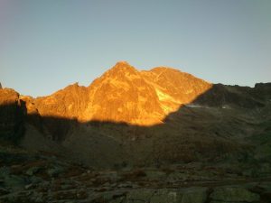
FOTO: ZCR VT
Ascent to Pyšný štít
Pyšný štít is located between Malá Studená dolina and Medená kotlina and it’s the biggest peak in the ridge from Baranie rohy to Lomnický štít with an altitude of 2623 meters above sea level. It is adjacent to Malý Pyšný štít. They are separated by a Pawlikowského štrbina and Lastovičia štrbina, between which there is a rock needle Loktibrada.
Climbing it is one of the most challenging. The classic route starts at Hrebienok, from where we ascend along the marked hiking trail to Téryho chata.
From there, the ascent follows as the route Jordánova cesta, but higher in the couloir we turn into Bachledova štrbina and ascend to the peak Pyšný štít.
From the top of Pyšný štít we descend back along the ascent route, or we can descend to Téryho chata via Malý Pyšný štít. From the top we have wonderful views of the entire Malá Studená dolina with all the tarns Spišské plesá, from the other side we see, for example, the tarn Zelené pleso and the Belianske Tatras.
The more advanced can choose to ascend to Pyšné štíty. They’ll first ascend to Malý Pyšný štít, then to Pyšný štít with a transition along the ridge to Lomnický štít with a descent route to Lomnické sedlo.
Total Ascent: 1400m
Difficulty: medium to difficult
Duration: circa 10 hours
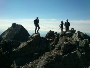
FOTO: ZCR VT
Ascent to Satan
The ascent to Satan 2432 meters above sea level is not one of the technically demanding ascents, but there is no marked hiking trail leading to it. It is a sought-after and popular hike also thanks to the beautiful views that are offered from the top.
Satan is the highest peak in the ridge Hrebeň bášt and has two almost equally high peaks – north and south. It’s separated from Čertov hrb in the massif Diabloviny by Satanovo sedlo and from Predná bašta by Sedlo nad Červeným žľabom. The ridge divides the Mlynická and Mengusovská valleys.
The hike to the top of Satan begins at Štrbské Pleso, from where we continue to Skok Waterfall and higher to Mlynická dolina. We walk around Pleso nad Skokom and for about an hour we continue along the marked trail in the direction of Bystrá lávka to Zadná Poľana to tarns Volie plieska. At this point, we turn off the hiking trail and head under the west wall of the Satan massif. From this place, already tied to a rope, we traverse the individual grooves and walls and ascend to the ridge and the top of Satan.
Total Ascent: 1070 m
Difficulty: easy
Duration: 6 – 8 hours

FOTO: Martin Maličký
Ascent to Prostredný hrot
The ascent to Prostredný hrot 2441 meters above sea level is one of the more demanding ascents.
Stredohot is the highest peak of the Prostredný ridge, which extends from the main ridge of the High Tatras to the south as a side arm of the Široká veža. The ridge separates the Malá and Veľká Studená valleys. Its name points to the location of the peak itself in the middle of these two valleys.
Several ascent routes lead to the top of Prostredný hrot. The ascent begins at Hrebienok, from where it is clearly visible, continues along the chalet Zamkovského chata in the direction of Téryho chata.
The most used is the route from Malá Studená dolina through Sedlo pred Prostredným.
A more exposed ascent over the Dubkeho lávka is also popular, or both routes tend to combine, one on the ascent and the other on the descent.
Total Ascent: 1157 m
Difficulty: difficult
Duration: 8 hours
By more technically demanding climbs, one leader can lead a maximum of 2 people.

FOTO: ZCR VT
Ascent to Kežmarský štít
Ascent along the regular route from Skalnaté pleso to Kežmarský štít (2556 meters above sea level) is one of the moderately demanding ascents. The Vidlový hrebeň (ridge) separates it from Lomnický štít. In Kežmarský štít, the fork of Lomnický štít is divided into a south-eastern arm, the dominant feature of which is Huncovský štít. The northern arm is dominated by Malý Kežmarský štít. Its northern wall is the most sought-after and very demanding climbing terrain.
From Tatranská Lomnica to Skalnaté Pleso we can take a cable car. From there, we continue to Skalnatá dolina and through Huncovský žľab we ascend to Huncovské sedlo and from there along a rocky ridge to the top of Kežmarské štít, we return the same way.
However, there are more combinations to get to and from the top. We can walk along the marked trail to Veľká Svišťovka. From there we turn left and get to Kežmarská kopa – ascent to Malý Kežmarský štít. From Malý Kežmarský štít we descend to Vyšná Kežmarská štrbina, which separates both peaks and from there to the top of Kežmarský štít. We can descend through the Huncovský štít, or go the other way around.
There are several ascent and descent routes, the exact route plan can be agreed directly with the mountain guide.
Total Ascent: 800 m
Difficulty: II – medium
Duration: 8 hours
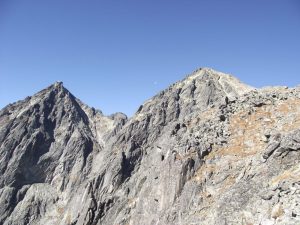
FOTO: ZCR VT
Ascent to Ganek
Ganek is a peak in the main ridge of the High Tatras with three peaks, which rises above three valleys – Rumanová (connected to Zlomisková dolina), Ťažká and Kačacia. The last two are connected to the peak with extremely steep and impressive walls. Ganek has an altitude of 2462 meters above sea level and is most accessible from Zlomisková dolina. The technically demanding ascent with exposed passages begins at the hotel Chata pri Popradskom plese. We continue through Zlomisková dolina to Rumanová dolinka, from there to Gankova štrbina and south-east ridge to the top. Ganek is also well known for Galéria Ganku (“Ganek Gallery”) – a vertical wall about 300 meters high with a number of climbing routes of varying difficulty. For demanding and capable tourists it is possible to climb Ganek, Rumanov štít and Zlobivá.
Total Ascent: 1100 m
Difficulty: difficult
Duration: approx. 8 hours
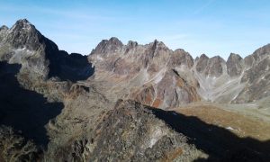
FOTO: ZCR VT
Ascent to Končistá
Končistá with an altitude of 2538 meters above sea level lies in the southern neighboring side ridge of Popradský Ľadový štít in the High Tatras. In the east, the ridge descends to Batizovská dolina, in the west to Štôlska dolina. The highest of the three peaks of Končistá is called Jármayho stôl („Jármay’s table“). Until recently, it was a bizarre boulder, which can also be seen from the Batizovská dolina. It resembled a horse’s head or a blacksmith’s anvil. In September 2019, however, the anvils were damaged by lightning.
Končistá is very easily accessible. In the tourist guides, the authors mention it as the most easily accessible peak among the main peaks of the High Tatras. It was probably well-known long ago by treasure hunters, poachers, gold diggers. Before the First World War, mountain leaders spoke of it with respect, and it is said that it is “climbable even on a dying horse”.
Nowadays, the ascent to Končistá begins from the Sliezsky dom or Popradské pleso. From Sliezsky dom we head to Batizovská dolina, around Batizovské pleso and on the southern slope of Končistá we ascend to the top. The descent leads to Lúčne sedlo and back to the Sliezsky dom.
Alternatively, we will start at the Chata pri Popradskom plese, get off at Ostrva and continue in the direction of Batizovské pleso. We can arrange the ascent and descent routes directly with the mountain guide.
Total Ascent: 1000 m
Difficulty: II – easy-medium
Duration: approximately 8 hours
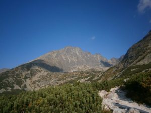
FOTO: ZCR VT
Ascent to Baranie rohy
Ascent to Baranie rohy, 2526 meters above sea level, is one of the simpler hikes. It is a sought-after and popular tour in summer or winter.
This massive peak stands about a hundred meters from the main ridge of the High Tatras. It has two peaks on the top plateau – southeast – main and northwest. They rise above the Valley of Päť Spišských plies, above Veľká Zmrzlá and Čierna dolina.
Baranie rohy are among the most easily accessible, albeit for hikers unmarked peaks over 2,500 m above sea level. Regular ascent leads either:
- from Chata pri Zelenom plese via Veľká Zmrzlá dolina and via Baranie sedlo,
- or from Téryho chata through the Basin of Päť Spišských plies and through Baranie sedlo,
- ascent and descent can also be combined
Total Ascent: 1250 m
Difficulty: average
Duration: circa 8 hours